The Bhutanese Leading the way.
A lucky save for Bhutanese Pilgrims
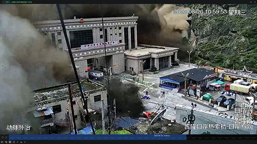
The floods in Nepal and Tibet caused by a massive glacier collapse generating an earthquake of 5.2 magnitude and a wall of water, rocks and mud have led to 579 deaths in Nepal and five deaths in Tibet (China).
As of Friday evening, the missing are close to 2,000 in Nepal and 558 in Tibet. The death and missing figures could go up.
The first major impact of the flood was in Kyirong on the Nepal-Tibet border completely wiping out the land port and burying 558 people, of whom 260 were tourists and pilgrims.
This could easily have been Bhutanese pilgrims because as of Friday evening there are five Bhutanese groups in Tibet most of whom either just travelled up through Kyirong or planned to come back down through it not far from the disaster date of August 26.
Sonam Tobgay of Sem-Zang tours said including him there were 12 Bhutanese who used the Kyirong pass on August 20 to enter Tibet.
The plan was to go back to Kyirong on September 4 again, but now they will come via air to Kathmandu.
He said he is aware of a bigger Bhutanese group of 23 people that also came via Kyirong around August 21 or so and had been to Samye Monastery.
A third group led by Norbu of nine people said they flew in on Thursday 27 August from Kathmandu with a plan to exit via Kyirong on September 6.
Norbu said he heard a fourth Bhutanese group is in Shigatse in Tibet.
Norbu said he saw a fifth group of Bhutanese in Lhasa. It is highly possible that they may have also come via Kyirong recently given it is a popular entry pilgrimage route for Bhutanese.
Sonam Tobgay said they heard the news in Tibet and the group was disturbed as they had just been through the check post. He, however, clarified that the main town of Kyirong which is much higher and 30 km away from the gate was not destroyed though the water had a backflow of around 2 km. He said in Tibet the news was widely discussed there, especially as people had lost relatives and friends in the flood including a person who lost seven people known to him. He said the people were saddened and disturbed.
Norbu whose group was in Kathmandu when the flood struck said the people there were also shocked with the flood and saddened by the loss of lives. He said the locals there said that they had never seen a flood of this size in their entire lives.
Back in Bhutan in the wake of the catastrophic floods that struck Nepal and Tibet (China) on 26th August 2026, anxieties have rippled across Bhutan regarding its own vulnerability to similar climate-induced disasters.
National experts warn that the threat of Glacial Lake Outburst Floods (GLOFs) continues to loom large over the country, bringing stronger urgency to the state of Bhutan’s Early Warning Systems (EWS).
The disastrous flash flood along the Nepal-Tibet border, triggered by a massive rock-ice avalanche and glacial collapse that sent water levels surging over seven meters in minutes, has underscored a grim reality for the wider Hindu Kush Himalaya region.
According to analyses by the US Geological Survey (USGS) and international scientific bodies like the International Centre for Integrated Mountain Development (ICIMOD), unseasonably high temperatures and accelerated global heating are dangerously destabilizing high-altitude permafrost and glacial walls.
As climate change drives rapid glacial retreat and swells alpine lakes, scientists warn that transboundary river basins across the Himalayas face an escalating threat of sudden, highly destructive outburst events that recognize no national borders.
The National Centre for Hydrology and Meteorology (NCHM) confirms that Bhutan shares the same fragile Himalayan geography and cryosphere dynamics as the region affected in Nepal, leaving the country susceptible to parallel risks.
“We are in the Himalayan region and we are geographically in the same area, and our cryosphere is also the same, so there is a risk,” said Karma Toeb, Chief of the Cryosphere Division at NCHM.
However, he noted that precise prediction remains a challenge: “We cannot say definitively, and we need a lot of external factors to determine results, like temperature that affects GLOF.”
High-risk basins and aging infrastructure
According to NCHM, Bhutan currently monitors 17 potentially dangerous glacial lakes spread across major river basins. The breakdown includes 11 high-risk lakes along the Punatsangchhu basin (nine in Pho Chhu and two in Mo Chhu), three in the Mangde Chhu basin, and two in the Chamkhar Chhu basin.
Topography compounds these risks. “Our lakes are like table mountains and are at the base,” Karma Toeb explained. “The slopes are very steep, and glaciers can detach and fall into the lake. These are expected phenomena.”
Compounding these natural hazards is the aging state of Bhutan’s EWS network. Systems installed in the Punatsangchhu basin back in 2010–2011, alongside those in Mangde Chhu and Chamkhar Chhu set up in 2015–2016, are increasingly outdated.
Basic monitoring setups have since been extended to areas like Amo Chhu, Paro, and Haa, but infrastructural gaps remain glaring.
“We see that communication is very important,” said Karma Dupchu, Director General of NCHM. While Punatsangchhu and Mangde Chhu rely on satellite communication, systems in Thimphu, Paro, and Amo Chhu depend on GSM networks, creating communication bottlenecks and connectivity vulnerabilities during severe weather.
Furthermore, commercial satellite subscriptions for the Punatsangchhu system carry heavy recurring annual costs. NCHM highlights that extending national telecom infrastructure all the way to Luggye Tsho could drastically reduce these recurring costs by making domestic telecom networks the primary communication mode.
A multi-sectoral challenge
Officials emphasize that an effective EWS extends far beyond simply installing physical sensors.
“EWS is not only about installing sensors, but there are categories that need to be included, such as hazards and risks, monitoring, communication, and dissemination,” Karma Dupchu stated. “We should know the hazard, monitor it, collect data, and then it must be disseminated.”
The importance of EWS is also apparent in the Nepal floods, and this serves as a wake-up call.
With over 70 percent of Bhutan’s settlements located along river valleys, safeguarding lives requires a shared burden. “If they are already in vulnerable areas, there needs to be equal responsibility from the public and government as well for the EWS to truly work and to save lives,” Karma Dupchu added.
Explaining the need for improved connectivity, Karma Dupchu shared that on 9th August 2026, a small flood occurred at Jichu Drakey. The initial alert was raised manually by a local herder, highlighting how crucial rapid communication channels and mobile connectivity are for remote high-altitude communities.
Currently, High Frequency (HF) and Very High Frequency (VHF) wireless systems are used in elevated areas, but they require scheduling and are limited by distance.
Lessons from the past and looking ahead
While the recent disaster in Nepal captured global headlines due to its massive scale, Bhutan is no stranger to these events. In 2023, a minor GLOF occurred at Thorthomi.
“That was exactly what happened in Bhutan and Nepal; only the difference was the scale,” Karma Toeb noted. “The scale of the ice collapse was much bigger in Nepal this time and quite smaller in our case.”
Systemic challenges persist for NCHM. Operation and Maintenance (O&M) rely heavily on international funding sources such as the Green Climate Fund (GCF), the Government of India, and JICA, alongside government support. NCHM continues to face human resource constraints, maintenance hurdles for remote telecom networks, and recurring cost pressures.
Meanwhile, when asked for an update, international funding proposals aimed at relocating vulnerable communities, such as the planned resettlement of Thangza and Toenchey villages in Lunana, remain unapproved.
In one of The Bhutanese’s recent coverages, the Department of Environment and Climate Change (DECC) said that the DECC submitted a proposal to secure USD 7.9 million to the Fund for Responding to Loss and Damage (FRLD), an entity under the United Nations Framework Convention on Climate Change (UNFCCC) which finances initiatives to help vulnerable communities to recover from climate-induced losses and damages.
If the funding request is approved, the DECC said that the relocation of the Lunana communities of Thangza and Toenchey is expected to begin as early as 2027, with resettlement targeted for completion by 2029.
NCHM officials express concern that international events like the Nepal floods might shift funding priorities, with discussions surrounding the proposal reportedly postponed beyond this year’s COP31.
NCHM is also planning its next pilot siphoning project for the natural outlet of a targeted lake during the first week of September, aiming for a more cost-effective approach.
Despite these hurdles, NCHM has secured a USD 22–25 million support package from the Green Climate Fund to upgrade and expand early warning systems across all major river basins.