The Bhutanese Leading the way.
NCHM plans to use drones to survey and assess potentially dangerous lakes
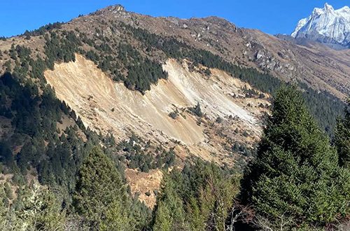
A newly formed artificial lake above Taktsimakhang in Gasa on the Sintaphu Chhu has burst following landslides from nearby slopes, causing its water level to drop substantially, although no casualties or damage have been reported so far.
According to local government sources, the lake burst on 6th November 2026 and the water level has decreased considerably. The water flow, which increased sharply following the incident, has since returned to normal.
The Director General of the National Center for Hydrology and Meteorology (NCHM) clarified that the newly formed lake above Taktsimakhang is separate from the artificial lake of Lungu Chhu/Gangchen Tag Chhu also above Taktsimakhang.
He said landslide material from nearby slopes fell into the newly formed lake, displacing the water that had accumulated there. This caused the water volume and outflow to increase suddenly. However, the flow has now returned to normal.
The Director General said landslides in the area remain highly active, urging communities downstream to remain vigilant.
A joint technical team from NCHM and the Department of Geology and Mines (DGM) continued its field assessment of the landslide-dammed section of Sintaphuchhu on 6th November 2026.
Additional slope failures were observed at around 8:20 am while the team was conducting its assessment.
However, the team reported no substantial outflow of the river following the breach of the landslide dam.
The Department of Local Governance and Disaster Management (DLGDM), NCHM, DGM and Royal Bhutan Army (RBA) personnel at Taktsimakhang are closely monitoring the situation and assessing potential risks.
Meanwhile, the cause or trigger of the Glacial Lake Overflow Flood (GLOF) outburst from the upper Sintaphuchhu lake remains unknown.
The NCHM Director General said a helicopter was deployed to the site on 5th November 2026 to assess the possible cause, and the findings are awaited.
During a press briefing on 3rd November 2026, NCHM shared preliminary findings from satellite image analysis comparing images acquired before and after the outburst of the Sintaphuchhu lake.
The analysis showed that the surface area of the lower lake had decreased by approximately 73.03 percent, while its water volume had reduced by around 81 percent.
The upper lake’s surface area had decreased by approximately 9.55 percent, with its water volume declining by 5.39 percent.
In terms of water level, the lower lake had dropped by approximately 28 metres, while the upper lake had decreased by around 0.4 metres.
The combined remaining water volume of the two lakes was estimated at 3.1 million cubic metres, with approximately one million cubic metres in the lower lake and 2.1 million cubic metres in the upper lake.
The estimated combined flood volume during the outburst event was 4.8 million cubic metres.
The preliminary interpretation suggested that the outburst from the upper lake triggered or contributed to the outburst of the lower lake. However, the exact mechanism that initiated the upper lake’s outburst remains under assessment.
The Director General also said that the Taktsimakhang monitoring station of NCHM was completely washed away, while the Tashithang station was damaged beyond repair.
He said mobile network connectivity played an important role in the early warning and information-sharing process, as herders in the area had access to mobile networks and were able to share information immediately through groups, allowing authorities to receive updates on the situation.
The specialist of the cryosphere service division at NCHM, Karma, said that they conduct regular monitoring of potentially dangerous glacial lakes, with the frequency of assessments depending on the technical characteristics and risks associated with individual lakes.
He said that the Sintaphuchhu lake was last assessed in 2023, with its next assessment scheduled for the 2027 financial year. However, before the assessment could happen the GLOF incident occurred.
He added that the country has 17 potentially dangerous lakes spread across the northern regions, making it difficult to conduct annual field assessments of every lake.
He cautioned that similar incidents could occur in other river basins as well, including Chamkhar and Mangdechu, which also have potentially dangerous glacial lakes.
For the Lunana lakes, NCHM has already conducted extensive studies and assessments and installed sensors and early warning systems connecting the lakes to downstream communities.
However, the agency is now working to strengthen the system by incorporating visual monitoring measures, including night-vision cameras, as most glacial lake outburst floods occur during the night.
The Director General said colleagues who recently returned from field assessments had been tasked with enhancing the early warning system.
NCHM also plans to use drones to survey and assess potentially dangerous lakes, in addition to existing monitoring measures such as sensors, CCTV cameras, early warning systems and satellite imagery.
The cryosphere specialist said that Lunana lakes are particularly complex, with four lakes situated adjacent to one another, requiring continuous monitoring and assessment.
Authorities have advised downstream communities and stakeholders not to panic but to remain vigilant, avoid riverbanks and flood-prone areas, and exercise caution as monitoring of the Sintaphuchhu area continues.