The Bhutanese Leading the way.
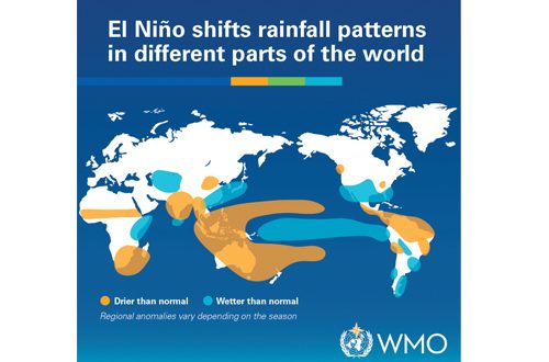
As global climate models project a near 100 percent certainty that a super El Niño phenomenon will persist until February 2027, Bhutan is bracing for a volatile stretch of weather for the rest of the month.
According to the latest El Niño updates from the National Center for Hydrology and Meteorology (NCHM), the forecasts that the coming weeks may feature week-by-week shifts in rainfall and localized temperature spikes across the country.
What weather to expect in the coming weeks?
While El Niño typically favors warmer conditions and below-normal rainfall across much of South Asia, its local manifestations are proving to be complex. NCHM’s forecast maps out a shifting pattern through September and early October:
The First Week (3rd–10th September): Above-normal rainfall is expected nationwide, accompanied by normal maximum and minimum temperatures.
The Second Week (10th –17th September): A sharp dry weather takes over, bringing below-normal rainfall across most of the country, though isolated pockets may see above-normal levels, southern regions are expected to face hotter-than-average temperatures.
The Third Week (17th –24th September): The east and southeast will experience above-normal downpours, while the rest of the country sees a drop in rainfall, alongside isolated wet spots in the west.
The Last Week (24th September–10th October): Heavy precipitation returns broadly across the country as above-normal rainfall takes hold heading into October.
Overall, meteorologists note that the month may have heavy downpours in the first and last weeks, contrasted with a drier mid-month window. Meanwhile, southern, southwestern, and central valleys can expect hotter days as maximum temperatures climb.
Globally, the World Meteorological Organization (WMO) reports that sea surface temperatures in the tropical Pacific are rising significantly and are projected to peak between November and December 2026.
Local forecasters emphasize that El Niño is not acting in isolation. A positive phase of the Indian Ocean Dipole (IOD) is anticipated to develop, reaching a mean value of 0.9°C between September and November 2026, alongside a warm equatorial Atlantic basin. These converging oceanic forces could potentially reinforce, alter, or partially neutralize typical El Niño impacts in the region.
Preparing for vulnerable sectors
With autumn serving as a critical period for agricultural harvest, hydropower energy generation, and tourist arrivals, NCHM, in a recent El Niño conference, highlighted that fluctuating weather patterns could trigger localized vulnerabilities.
“If there is less rainfall, then these sectors may be affected and relevant departments and sectors must be prepared to tackle them,” an NCHM official noted during a recent press briefing, highlighting the need for cross-sector preparedness.
The Center remains vigilant regarding extreme weather risks driven by shifting ocean temperatures. Authorities and international organizations strongly encourage the public to monitor official updates and advisories regularly through media channels and the NCHM Facebook page.