The Bhutanese Leading the way.
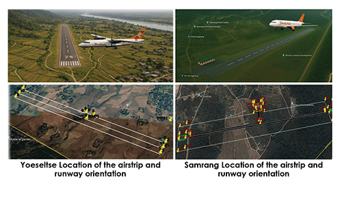
It has been learnt that the government has allocated Nu 1 billion (bn) for domestic airports in Yoeseltse in Samtse Dzongkhag and Samrang in Samdrupjongkhar Dzongkhag.
This does not mean the money is the final size of the two projects, which are expected to be well over Nu 1 bn, but the money is allocated so that some works can start until the final estimates come in later.
A senior official said that the first step is consultation with the people for the acquisition of private land for the two airports.
In Yoeseltse, the land required for a 1,500-meter-long airstrip is 75.719 acres, of which 65.384 acres is private land and 10.335 acres is government land.
The affected private land belongs to 77 households or Thram holders, of which 7.453 acres is Kamzhing and 57.931 acres is Chuzing. One built house structure is affected.
Various land compensation schemes will be looked at, from land replacement to financial compensation, while any fruit trees and structures will also be compensated.
In the case of the Samrang airstrip, the area required for a 2,000-meter-long runway is 168.445 acres, of which total private land is only 12.576 acres, affecting 14 households. Another 136.855 acres is leased land under a Land User Certificate given to the Bhutan Livestock Development Corporation (BLDC), and 19.014 acres is state land. However, here 14 houses will be affected as they fall within the airport area.
Both the airports are being built to be able to accommodate an ATR, which is the same aircraft used by Druk Air for domestic operations in Gelephu, Bumthang and Yonphula.
Both airstrips are located in the southwestern and southeastern parts of Bhutan and share similar features in terms of geographical terrain and meteorological conditions.
Both sites are located in proximity to the international boundary.
All basic amenities, including road access, electricity and water, are available in the vicinity of the airstrip sites.
A topographic design survey and geotechnical study will be conducted to initiate the airport design process and determine the required cut-and-fill earthwork volumes.
The feasibility study does not cover traffic analysis, economic viability and environmental aspects.
Yoeseltse
The feasibility report says the topography of Yoeseltse is characterized by relatively flat terrain with an elevation difference of approximately 32 meters between the two ends of the airstrip.
The proposed airstrip can accommodate a runway length of 1,500 meters. Extending beyond this length would encounter unsuitable topography, potentially leading to a significant increase in earthwork requirements.
The demarcated airstrip area includes provisions for runway safety margins, such as the runway strip, runway end safety area (RESA), and a taxiway linking the apron to the runway. It also accommodates an apron for aircraft parking along with essential amenities like a passenger terminal, car parking and other necessary services.
The slope of the natural topography at the airstrip site is approximately 2.13%, indicating that the area has a relatively gentle formation. However, this slope applies only to the longitudinal direction, extending from one end of the airstrip to the other along the centerline. It does not account for the transverse slope of the site and therefore does not provide a complete basis for estimating construction volumes.
The relative humidity is also high during the monsoon period, which indicates the presence of different types of clouds like nimbostratus, cumulus and cumulonimbus. It also suggests the possibility of fog formation during the early hours, thus decreasing visibility. An onsite observation for this is required over a longer period than the site visit duration.
The wind conditions are generally considered stable, similar to Gelephu. An average daily rainfall of 150 mm in summer means there is a need for a proper drainage system for the airstrip construction to avoid flooding in the region.
The visibility around the Yoeseltse airstrip site is impacted by the wind direction due to nearby industrial activities, which are mostly hazy because of pollution. However, the general visibility around the region is good, based on visual observations, indicating feasible conditions with respect to visibility. It is important to consider that an increase in industrial activities could lower visibility. Furthermore, the presence of open water surfaces could also influence visibility during the early hours due to the mixing of fog.
Samrang
The topography of Samrang is relatively flat with an elevation difference of approximately 8 meters between the two ends of the centerline of the airstrip.
The proposed airstrip can accommodate a maximum runway length of 2,000 meters.
The slope of the natural topography at the airstrip site is approximately 0.4%, indicating that the area has a relatively gentle formation. However, this slope applies only to the longitudinal direction.
This airport too needs a good drainage system to prevent flooding during the monsoon.
The high relative humidity during the monsoon season suggests the potential for fog formation, especially in the early morning and evening due to abundant moisture in the atmosphere. Additionally, cloud cover, particularly low-lying clouds like nimbostratus, can reduce visibility.
Visibility at the Samrang site was visually assessed over three days during the morning, noon and evening. Across all directions, hazy conditions were consistently observed, with zero cloud cover in the early mornings. Visibility was around 2 km in the southeast direction during the morning and evening, improving slightly at noon.
The haze is likely due to industrial pollution from the nearby State Mining Corporation Limited (SMCL), and future industrial growth could further reduce visibility as pollutants are carried by the prevailing winds.
Additionally, during the monsoon, rising river levels may contribute to fog formation, especially in the morning and evening, due to katabatic winds and the presence of seasonal water bodies. While current visibility appears suitable for an airstrip, further investigation is needed into the effects of pollution and open water on long-term visibility.
Visibility at the Samrang airstrip site remained relatively consistent during observations, though pollution-induced haze was present. The impact of nearby open water on visibility has not been analyzed. As the weather data used was from a nearby station, the findings carry some uncertainty. To better understand local atmospheric conditions, the installation of an Automatic Weather Station (AWS) is recommended.