The primary technical phase of the geological and mineral mapping project of Bhutan, led by consultants Xcalibur Smart Mapping, has been successfully concluded said Mr. Phuntsho Namgyal, Director General, Department of Geology and Mines (DGM).
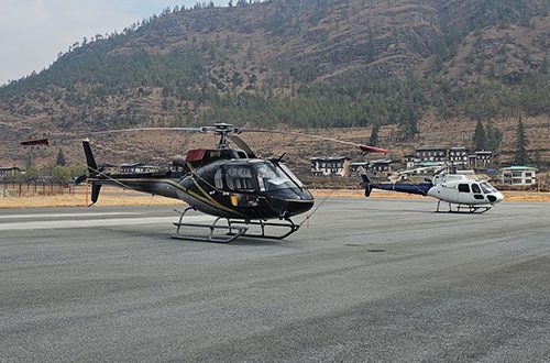
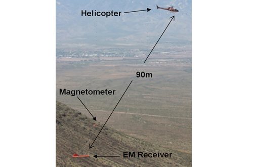
Utilizing two survey helicopters, the survey teams completed a total of 43,893 line-km. This exceeds the original contract requirement of 42,642 km, representing a 3% increase.
The survey has successfully mapped a total area of 15,567 sq.km, which accounts for approximately 40% of the country’s total landmass.
Following the comprehensive data collection, the specialized flight crews, survey helicopters and equipment officially exited the country on April 4, 2026, after securing the necessary transit permits from all relevant authorities.
Remaining Milestones
The project has currently transitioned from the operational phase to the analytical phase. The remaining key milestone is the Final Interpretation and Reporting are as follows:
“Our in-house experts, in collaboration with Xcalibur, are now synthesizing the airborne data with existing ground geological records. This will culminate in the Natural Resource Prospectivity maps at a 1:50,000 scale,” said the DG.
As the most labor-intensive and weather dependent phase (flight operations) is already complete, the Ministry is firmly on track to finalize the interpretation and complete all activities by June 2026 as planned.
This initiative marks the first time such advanced geophysical technology has been applied at this scale in our country. By bypassing years of traditional reconnaissance and moving directly to data-backed targets, the Ministry is securing a sustainable and efficient roadmap for the nation’s mineral development.
Objectives and Data Processing
The primary objective of this strategic investment is to provide a comprehensive mapping of the nation’s lithology, mineral resources and structural framework. This data is critical for: Identifying high-potential mineral prospectivity zones, Mapping subsurface geological structures and Enhancing the national geoscientific database for sustainable resource management.
Xcalibur Smartmapping has concluded the primary processing of the collected data, ensuring that the raw inputs are refined into high-quality geophysical datasets.
Current Status and Data Accessibility
The project is currently in the interpretation phase. Technical experts are analyzing the processed data to delineate specific mineral prospects and geological anomalies.
The final interpretation report, which will identify significant high-potential zones, is scheduled for submission by June 2026. Following the internal review and validation of these results by the Department, the government will determine the framework and timeline for making this data commercially and publicly actionable to support the nation’s economic objectives.
While traditional exploration methods across the entire country would require decades of work, the airborne survey has provided a comprehensive “big picture” by identifying specific geophysical anomalies. This allows the Department to pinpoint high-priority targets and initiate a Focused Exploration Phase to maximize the economic value of the data.
To translate these findings into actionable mineral prospects, the following technical steps will be implemented.
There will be targeted Geochemical Surveys. Systematic soil, stream sediment, and rock analysis will be conducted specifically within the high-potential zones identified by the airborne survey. This allows for the detection of precise chemical signatures associated with mineralization.
There will be High-Resolution Ground Geophysics. To refine the targets identified from the air, the Department may deploy specialized ground-based methods, such as ERT or Ground base Magnetometer, as required. These techniques are essential to determine the precise depth, orientation, and geometry of potential ore bodies.
There will be Precision Geological Mapping. Field teams will carry out intensive structural and lithological mapping. This localized mapping is critical for understanding the geological controls of mineralization and is a fundamental step in determining the grade and quantity of the resource.
By utilizing the airborne data as a roadmap, the Department will effectively concentrate its resources on the most promising targets, significantly accelerating the timeline toward commercial mineral development and value-added exports. This approach avoids the significant expenditure of time and resources that would otherwise be required for undirected, large-scale exploration across the entire landmass.
Status of Mines and Minerals Management Bill 2026
While the absence of new legislation does not have major implications to existing mines and investors, the new bill will enhance and update some elements like promote environmentally friendly and socially responsible mining sector; introduce transparent and competitive allocation systems; strengthen provisions for value addition and sustainable mining practices; fully leverage the outcomes of the nationwide mapping initiative; promote benefit sharing mechanisms, and introduce progressive offences and penalties.
The Department and the Ministry said they do not anticipate any significant challenges arising from a potential timing misalignment between the approval of the new Bill and the realization of benefits from the nationwide airborne geophysical survey.
The current Act contains sufficient provisions to support the mandates of prospecting, exploration, and geological mapping. There is no substantive policy divergence in the framework governing mineral allocation and leasing. However, any detailed or unprecedented findings arising from the survey will be addressed through appropriate policy mechanisms, the specifics of which can only be determined once the survey results are finalized.