The Bhutanese Leading the way.
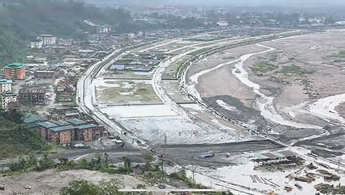
Recurring flooding in Phuentsholing is being driven by a combination of climate-induced changes and large-scale landslides, according to the Minister of Infrastructure and Transport.
Responding to a question during the 29th Meet-the-Press session held on 3rd July 2026, Lyonpo Chandra Bdr Gurung said that increased rainfall intensity and frequency linked to climate change have led to higher surface runoff, landslides, and debris flow events in the region.
Lyonpo said that the recent flooding in the Amochhu area was primarily triggered by a massive landslide, resulting in the discharge of large volumes of debris rather than conventional floodwater.
Initial assessments further suggest that the volume of sediment deposited is exceptionally high and may continue to increase over time.
Lyonpo Chandra said that geotechnical studies in Phuentsholing show the area is highly susceptible to landslides.
In particular, investigations on the Chamkuna hillside adjacent to the Amochhu Local Area Plan indicate that around 80 percent of the area consists of inactive landslides that could be reactivated even by minor disturbances.
He said the Amochhu River has historically been flood-prone, but risks have increased due to intensified rainfall in the upstream catchment areas.
He added that development activity has also contributed to localized flooding in some areas, although the recent incident was predominantly caused by the landslide event.
The Ministry of Infrastructure and Transport (MoIT) said the government’s current approach focuses both on disaster preparedness and long-term mitigation measures, given the increasing frequency and complexity of such events.
Preparedness
MoIT said flood protection works have been implemented in downstream areas under the Phuentsholing Township Development Project (PTDP Zone A), which were effective during flooding in October last year.
However, areas under PTDP Zone B remain inadequately protected and were significantly affected during recent flood events.
The Department of Geology and Mines (DGM) has initiated river dredging and emergency flood protection measures in affected areas, while the National Center for Hydrology and Meteorology (NCHM) is working with local authorities to monitor river levels and strengthen early warning systems.
Out of 13 outfalls along the Amochhu and Chamkuna stretch, Open Outfall 1, Outfall 3 and Outfall 5 have been identified as high-risk zones.
A comprehensive hazard and risk assessment of the hillside along the Amochhu LAP and Chamkuna area has been underway since 2025 under the ADB-supported technical assistance project, ‘Building Adaptation and Resilience in the Hindu Kush Himalayas, Bhutan and Nepal.
Long-term measures
MoIT outlined several long-term interventions being considered or implemented.
These include strengthening policy and regulatory controls on hillside development, particularly within the Dungkhag area, and establishing urban buffer zones along vulnerable slopes in coordination with relevant agencies.
The ministry also highlighted the need for a dedicated sediment management plan, citing recurring sediment accumulation at key outfalls.
While annual dredging has been carried out by the Thromde, the scale of debris from recent landslides requires a more comprehensive removal and disposal strategy, which is being prepared with support from the DGM.
In addition, MoIT said a new bridge is being planned at Open Outfall 1, as the existing structure is not designed to handle the magnitude of landslide debris and flooding now being experienced.
A detailed catchment assessment will be required to ensure the design does not obstruct natural sediment flow.
The ministry also recommended promoting flood-resilient building designs in high-risk areas, including stilt-based structures that allow water and debris to pass underneath, thereby reducing risks to life and property during extreme monsoon events.
MoIT said these combined measures aim to strengthen both immediate preparedness and long-term resilience in Phuentsholing, given the increasing exposure of the region to climate and geophysical risks.