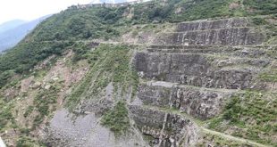
The recent 5.5-magnitude earthquake on the 7th June night with its epicentre around 20 km under the surface near Punakha Dzong is another not-so-gentle reminder of Bhutan’s vulnerability to earthquakes.
Bhutan may have accumulated significant tectonic stress over the past three centuries since a magnitude 8.0 earthquake struck the country in 1714, according to the Department of Geology and Mines (DGM), which says the country remains highly vulnerable to future earthquakes due to its location within the active Himalayan seismic belt.
The DGM explained that Bhutan lies within a seismic gap along the Main Himalayan Thrust (MHT), a section of an active fault that has not experienced a major earthquake for a long time. The last major earthquake along the MHT with its epicentre in Bhutan occurred in 1714 and is estimated to have had a magnitude of around 8.0.
Long periods without major earthquake activity allow tectonic stress to accumulate, which may eventually be released in the form of another major earthquake.
Historical earthquake records further highlight Bhutan’s seismic risk. Since the 1714 earthquake, there have been no known earthquakes of a similar magnitude with an epicentre in Bhutan. Given that major Himalayan earthquakes typically have a return period of between 300 and 500 years, DGM noted that significant stress may have accumulated over the last 300 years.
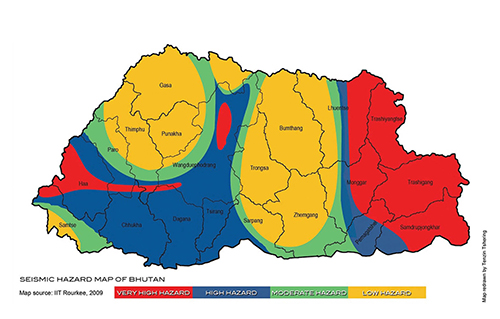
According to the department, the entire country is prone to strong ground shaking from earthquakes. Bhutan is surrounded by several major active fault systems that have generated strong to major earthquakes in the past. The most significant of these is the MHT, an active tectonic boundary where the Indian Plate is actively underthrusting beneath the Eurasian Plate. This subduction zone can be traced along southern Bhutan and extends beneath the country towards Tibet in China.
While major earthquakes are relatively infrequent, minor seismic activity is recorded regularly across the country. The National Earthquake Monitoring Network of Bhutan records around 180 micro-earthquakes annually, averaging about 15 events per month. These earthquakes occur in and around Bhutan due to the presence of several major active fault systems and numerous smaller faults associated with Himalayan subduction.
DGM stated that most of these events are low-magnitude tremors, typically below magnitude 3.0, and go unnoticed by the public. However, the tremors are detected by sensitive monitoring instruments and provide seismologists with valuable data on local stress accumulation.
To monitor seismic activity, Bhutan relies primarily on the National Earthquake Monitoring Network (NEMN), established in 2015. The network consists of 14 seismic stations and 222 earthquake intensity meters installed across the country. This includes 20 intensity meters located in dzongkhag administration offices and 202 intensity meters distributed among gewog administration offices.
The monitoring system uses seismometers and accelerometers to record seismic waves, with data transmitted in real time to the central observatory housed within DGM in Thimphu. The network supports earthquake detection, intensity measurement, and disaster response efforts.
The DGM also collaborates with several international institutions and researchers to strengthen Bhutan’s seismic monitoring capabilities. Historically, the department has worked under Japan-funded projects supported by the Japan International Cooperation Agency (JICA) and the Science and Technology Research Partnership for Sustainable Development (SATREPS). These initiatives played a key role in establishing Bhutan’s initial National Earthquake Monitoring Network, constructing seismic stations, and installing intensity meters nationwide.
Building on these efforts, the DGM has recently submitted comprehensive proposals to further enhance and densify the national seismic network to capture more precise local data.
Currently, the department is collaborating with the University of Texas at El Paso (UTEP) in the United States, on a project funded by the National Science Foundation. The initiative uses seismic data and localized sensors to detect subsurface vibrations and sediment transport caused by glacial movements. By analysing these distinct seismic signals, the collaboration aims to improve the accuracy and warning times of Glacial Lake Outburst Flood (GLOF) Early Warning Systems to better protect vulnerable downstream communities. The department also cautioned the public against relying on social media claims about impending earthquakes. The DGM advised people to verify earthquake-related information only through official and scientific sources such as the DGM, the Department of Local Governance and Disaster Management (DLGDM), and international agencies such as the United States Geological Survey (USGS).
According to the department, social media claims predicting earthquakes are not credible because current scientific knowledge does not allow earthquakes to be accurately predicted in terms of their exact time, location, or magnitude. Such posts are often misinformation and should not be relied upon.
Bhutan, for a while, had been resting easy due to some earlier studies that said that the likelihood of a major earthquake of magnitude 7 or 8 hitting Bhutan was minimal after the seismic activity zone had shifted to about 180 km from the Himalayan foothills to the Shillong plateau, making Bhutan safer.
However, a seven-yearlong study on Bhutan’s geodynamics from 2011 to 2018 came out with new findings that an earthquake of such magnitude could hit Bhutan in the future.
An international research team in collaboration with the Department of Geology and Mines, found that although the seismicity rate in Bhutan has been low over the decades, they have, however, discovered evidence that at least one earthquake of a magnitude 8 had actually occurred in Bhutan in the past that was much stronger than any recent events- corroborating some earlier studies forewarning that an earthquake of such magnitude can occur again.
The team by 2018 found that the numerous low-magnitude seismic events that Bhutan experienced are not capable of releasing the built-up stress that has been developing over the centuries.
Even within the scientific communities, there is a clear understanding that an earthquake of magnitude 6 or 7 will not be able to release the stress accumulated over the years along the contact points of the shifting Asian and Indian sub-continental plates.
There has to be an earthquake of magnitude 8 or higher in order to release the built-up stress, and no such earthquakes had hit the area in many centuries in the region.
However, people should not panic as it is not known when the quake will hit but it is important that all precautions be taken from following building codes to having earthquake drills to post quake measures.
The Prime Minister Dasho Tshering Tobgay assured in Parliament on 8th June that there was no major damage from the earthquake, but he said the quake was a reminder for the government to prepare for a major earthquake in the future.
Lyonchhen said His Majesty The King has been reminding the government to prepare for the major quake of the future.