The Bhutanese Leading the way.
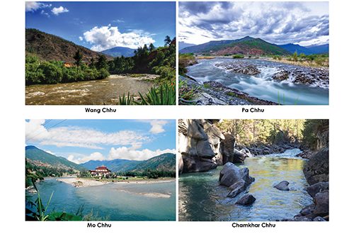
As the Himalaya bears the brunt of accelerated warming and erratic monsoons, catastrophic cloudbursts and glacial lake outbursts have transitioned from theoretical models to grim regional realities.
Following devastating flash floods in neighbouring Nepal, where transboundary data gaps and sudden wall-of-water events overwhelmed communities, Bhutan faces an urgent reckoning. With over 70 percent of settlements, infrastructure and agricultural land located along the country’s fragile river valleys, data from the National Center for Hydrology and Meteorology (NCHM) shows that Bhutan also faces significant vulnerabilities.
Experts at NCHM said Bhutan, being in the same Himalayan belt as Nepal, faces similar flood risks. In worst-case scenarios, there are also highly catastrophic events that could affect the country.
Punatsangchhu, Paro and Bumthang
According to the UNDRR Disaster Risk Report of Bhutan, over 70 percent of settlements, infrastructure and agricultural land are located along river valleys. GLOF and flood risks are also closely tied to Bhutan’s major river basins.
The Punatsangchhu river basin remains the most risky river basin when it comes to GLOF and flood risks, as it brings together 11 potentially dangerous lakes from the Pho Chhu and Mo Chhu and becomes one of Bhutan’s largest downstream river systems.
Thorthomi Tsho is classified as a critical lake. In a worst-case scenario, NCHM says that an outburst from Thorthomi could also breach the moraine walls of neighbouring Rapstreng Tsho and cause a cascading effect, resulting in a “combined GLOF” that would be more devastating.
The moraine walls separating Thorthomi Tsho and Rapstreng Tsho are only a few metres apart. The walls contain ice cores that are vulnerable to melting due to rising temperatures. This can cause seepage of water from Thorthomi into Rapstreng and lead to overflow.
Another worst-case scenario involves simultaneous flooding of both Pho Chhu and Mo Chhu, producing extreme water discharge from the two rivers, landslides, blockages and huge debris flows downstream. This makes Punatsangchhu especially critical.
NCHM Director-General Karma Dupchu said such events can happen and depend on several factors.
“Such events can happen. Sometimes glaciers are also underground and hard to detect and it will depend on many factors like earthquakes and avalanches,” he said.
He said people living downstream must remain vigilant and alert for the worst-case scenario.
“Risks remain in all the rivers and there are risks to much infrastructure and many livelihoods downstream,” he added.
Paro is also emerging as a significantly vulnerable area. The recent mini Jichu Drakey flood caused by the rise in its water level served as a wake-up call for the dzongkhag.
NCHM Chief of the Cryosphere Division Karma Toeb said it is concerning because the Jichu Drakey glacier is massive and the chances of unprecedented events remain.
A post-GLOF/flood assessment report by NCHM says the flood was first observed by residents at around 11am and was recorded by the Bondey station at around 11pm the same day, indicating a flood travel time of approximately 12 hours.
The breach occurred from a small glacial lake located 2km above the Jichu Drakey lake. Water released from the upper lake entered the englacial drainage system, meaning water flowing inside tunnels and shafts in the ice. The additional inflow caused the lake’s water level to rise and produced a temporary discharge.
Karma Tsho sits at the base of the gigantic Jichu Drakey glacier. According to the Flood Hazard Map of the Paro river basin, a Karma Tsho GLOF scenario could affect communities from the source, running down through the Jagarthang community area towards downstream settlements and infrastructure, including the Paro International Airport area and beyond.
The estimated water level depth could reach between 2m and 5m. As these areas in Paro are generally alluvial plains, they remain vulnerable to possible flood events.
Karma Toeb said a long-term plan is necessary.
“It is high time that we establish a long-term plan since the Jichu Drakey glacier is a huge one,” he said.
In Bumthang, the dangers of the huge Chubda Tsho loom over the valley. The potentially dangerous lake lies in the headwaters of Chamkhar Chhu.
A study titled “Two-Dimensional Hydrodynamic Modelling of Glacial Lake Outburst Flood Scenarios from Chubda Tsho: Breach Sensitivity and Downstream Flood Dynamics in the Chamkhar Chhu Basin, Bhutan” draws potential scenarios of a Chubda Tsho outburst at different water discharge intensities of 50 percent, 75 percent and 100 percent.
The observations of the study were inundated with data recorded during the 2009 Cyclone Aila events.
The simulations produced peak discharges of roughly 2,100 to 5,300 cubic metres per second, depending on the proportion of lake volume released based on 50 percent, 75 percent and 100 percent water discharge.
The modelled flood reaches the downstream Chamkhar valley in an estimated time of one hour and 50 minutes to two hours and 15 minutes.
The flood hazard map of Chamkhar Valley, under a Chubda Tsho outburst scenario, shows that areas lying near the river basin could be washed away, with flood depths rising beyond 2m.
Low-lying plain areas such as Bathpalathang Airport and Chamkhar Town, particularly those close to the river, remain heavily vulnerable.
Karma Toeb noted that there are many triggering factors that lead to GLOFs and rainfall-induced hazards.
Flash floods, Thimphu and eastern rivers
In the case of the river that flows through Thimphu, Thimchhu, there are no glacial lakes and only the significant Shodug glacier.
Karma Toeb said Shodug glacier does not pose a risk as it is surrounded by gentle slopes and a flat downstream valley.
Although Thimchhu does not have a conventional GLOF risk, there are chances of flash floods occurring from landslide-dam failures caused by heavy rainfall and sediment accumulation.
When these dams fail or breach, the accumulated sediments can trigger flash floods similar to the Dechencholing floods that occurred last year.
Karma Dupchu said these are natural phenomena that occur repeatedly in upstream rivers and generally in forests.
Greater caution also needs to be exercised in the eastern rivers.
According to NCHM, the Tsatichhu flash flood that occurred on 19 July 2026 at Lhadrong village in Lhuntse was caused by intense heavy rainfall combined with upstream landslides.
This led to the complete breach of an existing landslide-dam lake on the Tsatichhu stream.
Kuri Chhu contains one potentially dangerous lake called Terjatse Tsho. It was marked as a risky lake partly because another lake lies above the Tsho, which could be a potential triggering factor for a GLOF.
Additionally, Terjatse Tsho has a steep morphology at the outlet of the lake and could feed the Khoma Chhu before flowing into the Kuri Chhu downstream.
Eastern Bhutan is particularly marked by steep slopes and intense monsoon rainfall, making it highly vulnerable to rainfall-triggered landslides, accumulation of loose soil and the formation of artificial dams.
Amo Chhu and its transboundary hurdle
In the southern region, the Amo Chhu is a persistent river that causes constant flooding and river swelling, although it does not pose a conventional GLOF risk.
The Amo Chhu is also challenging because it is transboundary in nature, with its catchment extending into the high Himalayas under Chinese territory.
The Nepal floods also highlighted the lack of real-time upstream data from the Chinese side. Nepal relies heavily on such information, while China is hesitant to share it.
The southern region receives constant heavy rainfall, which leads to landslides that dump sediments and boulders into river confluences.
For the Amo Chhu, this can create a landslide-dam flood scenario where debris enters the rivers and blocks the channel. When the debris dam falls, towns such as Phuentsholing could be flooded.
Importance of communication and improving EWS
Some of these simulated events may be connected with a Nepal-style flood if they meet specific parameters and technical criteria. However, forecasting a GLOF or flood event in Bhutan is far from easy.
Rather than comparing Bhutan’s situation with Nepal, it is increasingly important to remain alert and cope with possible situations.
Karma Dupchu said communication is the most important aspect of disseminating information and warning others.
“Citizen science is a crucial element and the most effective form of information dissemination,” he said.
In Nepal, early warning system stations were washed away by the floods before they could signal the flood forecasting division.
According to the Nepali Times, the flood forecasting division only learnt of the flood through a telephone call from the District Administration Office and later from an observer at 9am.
By 9:15am, the first alerts were issued and, within one minute, more than 679,000 SMS messages were sent through telecom operators, alerting thousands before the debris hit downstream valleys.
This shows the importance of communication and shared responsibility between agencies and communities, as stressed by NCHM.
During the Jichu Drakey incident, a local herder observed the flood and immediately warned others.
NCHM said early warning systems in Punatsangchhu, Mangde Chhu and Chamkhar Chhu are closely monitored using satellite technology, automatic weather stations and water-level stations.
Warning sirens are also in place, along with a 24/7 monitoring team. Relevant procedures have also been established to streamline protocols during disasters.
However, existing EWS are generally very old and maintaining them is costly.
When asked whether NCHM can use new technology to improve monitoring, officials said it can, but the agency lacks funding and requires more attention from the government and telecom operators to expand networks and improve connectivity.
There is also a challenge in creating greater awareness. Mobilising people for awareness campaigns is difficult as residents are often caught up with their own work.
Expanding modern technology infrastructure requires greater funding, stronger government backing and deeper collaboration with telecom operators to widen connectivity networks.