The National Centre for Hydrology and Meteorology (NCHM) in Bhutan has taken a major step forward in flood risk management by incorporating drone technology into its flood prediction efforts.
The drones used by NCHM are equipped with LiDAR (Light Detection and Ranging) sensors that send out laser pulses to measure the distance to the ground. These measurements are used to generate highly detailed, 3D maps of the landscape. This technology is particularly useful for capturing precise data about elevation, land features, and small topographical elements like buildings and vegetation, which all play a role in how floodwaters move.
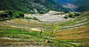
This innovative technology is transforming how flood-prone areas in Bhutan, such as Chamkhar Valley, are mapped and studied.
Flooding has long been a challenge in Bhutan, with heavy rains often leading to dangerous flash floods. The need for accurate flood prediction tools has become more pressing as climate change intensifies weather patterns, making flooding more unpredictable and severe. Traditionally, creating detailed maps of the land to model floods was a slow process, especially in Bhutan’s rugged terrain. However, with the help of LiDAR-equipped drones, NCHM has introduced a faster and more effective solution.
What makes this technology even more effective is the use of Real-Time Kinematic (RTK) positioning, which allows for accurate mapping without requiring additional ground control points (GCPs). This significantly speeds up the process and makes it easier to cover large, difficult-to-reach areas.
One of the key benefits of using drones for flood mapping is the accuracy it brings to flood predictions. By creating detailed terrain models, NCHM can simulate how floodwaters are likely to behave, which is crucial for effective flood risk management and planning.
In a recent study, flood predictions made using data collected by these drones were found to closely match real-world flooding events in Chamkhar Valley. This confirms that drone-generated data can be a reliable tool for flood forecasting.
While the current results are promising, experts at NCHM suggest combining drone technology with riverbed mapping and ground-based surveys to further improve the accuracy of flood predictions. As more data is collected, Bhutan’s flood models will become even more precise, helping to better prepare communities for future floods.
NCHM’s use of drone technology has set a new standard for how technology can be used to mitigate disaster risks and protect vulnerable populations from the impacts of flooding.