Global climate research institutes urge timely informed decision-making, planning and preparedness measures
International sources and news outlets confirm that El Niño has officially begun. The Secretary-General of the United Nations, Antonio Guterres, also addressed it by saying that El Niño “is at our doorstep”.
According to the National Oceanic and Atmospheric Administration (NOAA) Climate Prediction Center, it predicts a 63 percent chance of a very strong El Niño – a super El Niño – from November 2026 to January 2027.
The center also noted that the El Niño phenomenon this time would rank as one of the largest in history in the historical record going back to 1950.
Furthermore, the center says that El Niño is present and it is expected to strengthen the Northern Hemisphere winter of 2026-27.
For it to be considered a ‘Super El Niño’, tropical Pacific water temperatures hit more than 2 degrees above the average temperatures. CNN weather says that some models suggest the possibility of exceeding that number.
Moreover, Super El Niños are rarer events, occurring once in a while. The recent ones recorded were in 2015-16, 1997-98, and 1982-83.
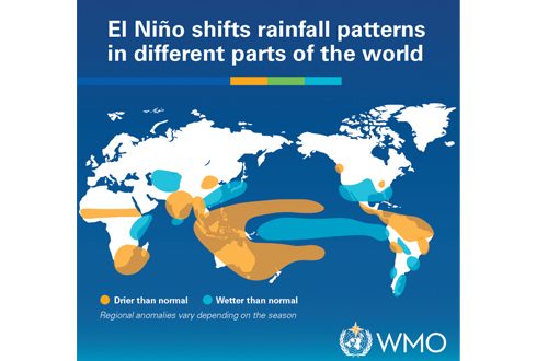
This weather phenomenon is expected to bring a range of climate impacts throughout the world, with its effects also being evident during the winter months.
CNN weather said that monsoon rain is reduced in India and Southeast Asia, and that there are signs of this already starting to occur. In these areas, reduced precipitation can exacerbate summer heat.
Additionally, hotter than usual temperatures may also harm agriculture and water supply in areas that are expected to suffer from burning temperatures.
As El Niño effects aren’t the same everywhere, there are risks of other unexpected events that may occur and follow.
International sources say that there is a heightened level of uncertainty about this Super El Niño as it is occurring at the same time when global temperatures are climbing up from the average due to global warming and fossil fuel pollution.
Therefore, there are also questions where this combination of weather and climatic events may turn extreme.
The National Center for Hydrology and Meteorology (NCHM), in its summer monsoon outlook for the 2026 summer season, predicts that the summer rainfall for Bhutan is likely to be normal to slightly below normal. Normal is the average rainfall for the summer season of Bhutan recorded from 1996 to 2025 of the months June, July, August and September (JJAS).
Additionally, the maximum and minimum temperature in Bhutan during the 2025 monsoon season is likely to be above normal. Normal is the average temperature (maximum and minimum) for the summer season (JJAS) of Bhutan from 1996 to 2025.
Evidently, as Bhutan enters the summer season, there are lesser indications of heavy rainfall in the country besides the southern region. Areas such as Thimphu feel drier than usual, with scantier and light rainfall.
NCHM’s weekly weather report dated 15-21 June 2026 says that the Indian Ocean Dipole (IOD) remains neutral currently and it indicates a positive IOD condition towards the end of the southwest monsoon season.
This means that the Indian Ocean is currently undergoing a warming trend and it pushes away the impacts of a positive IOD, which is a more active monsoon with above than normal rainfall towards the second half of the monsoon, typically during the end of the season.
For Bhutan, extreme weather patterns may enable climate impacts such as flash floods and landslides, while also affecting agriculture processes and hydropower generation. The paper will keep pursuing updates and details in different sectors.